70Nature and parks · Osogovo
Tsarni Kamak Peak
Your visit at a glance
- Address
- Osogovo, on the ridge between Kulitsite and Shapka
- Approximate time for the whole walking outing
- about 5 hours
- Visiting conditions
- No verified information found
- Admission
- No verified information found
The image could not load. Its caption and source remain available.

Tsarni Kamak, also labeled Tsaren Kamak, is an Osogovo peak with a cited elevation of 2,069 m. It forms part of the ridge between Kulitsite and Shapka, although summer trails to Ruen can traverse its slopes.
Hours, admission, and directions ↓
Tsarni Kamak is one of the high landmarks on the approach to Shapka and Ruen. Its name also appears as Tsaren Kamak, including on OpenStreetMap. These are variants for the same summit point on the route described here.
Between the lower and higher ridge
↗Evgeniy Dinchev and Petar Atanasov give an elevation of 2,069 m in their Osogovo guide. They trace the ridge south from Choveko to Kulitsite, then southwest through Tsaren Kamak and Shapka toward Ruen.
Tsarni Kamak thus lies in the transition from the lower ridge sections to peaks above 2,100 m. The elevation comes from the guide; the mapped point used here confirms its location and name but has no separate elevation entry.
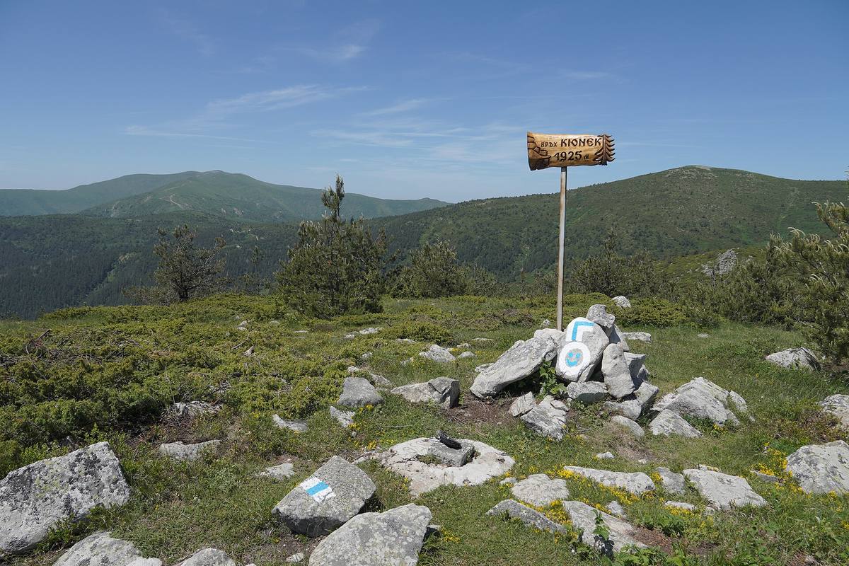
The gallery shows a view from Kyunek toward the high ridge. The photographer identifies Tsarni Kamak, Shapka, and Ruen in the left background. Kyunek’s cairn and sign occupy the foreground, an important detail for interpreting the photograph.
How the routes pass
↗The Mlad Planinar account of a hike to Ruen describes passing below Tsarni Kamak and the neighboring high point at 2,119 m. This is a useful distinction: a route to the mountain’s highest summit can pass beside this peak without reaching its top.
If Tsarni Kamak is your destination, check your chosen route on a map. A route called “to Ruen” does not by itself tell you which intermediate summits you will climb. The neighboring unnamed high point should also be distinguished from Tsarni Kamak, even though it is higher.
Pastures as a natural landscape
↗The Association of Parks in Bulgaria names Tsarni Kamak alongside Shapka and Kulitsite in its 2017 report. They feature among Osogovo’s summits and ridge pastures involved in a campaign concerning a national auction of state land. The report records a particular conservation initiative; it does not establish present ownership or access to every track.
Anna Gavrilova and Antonina Vitkova of the Bulgarian Academy of Sciences describe wind-exposed grasslands in the wider Ruen area in Hacquetia in 2010. Their research illustrates the botanical value of open ridges. It does not provide a separate plant inventory for Tsarni Kamak.
Before setting out
↗Osogovo Hut is the usual starting point. Allow around five hours for a walking visit, return, and breaks, depending on the particular approach. Check the waymarks locally and follow the forecast. The map marker identifies the summit, rather than a trailhead or parking area.
Traversing trails and ridge routes are different choices, particularly in snow. Avoid choosing a winter approach solely from a summer route or an old photograph. Bring a map and water. No published visitor schedule or admission tariff was found for the peak itself.
Sources
(5)
A date may refer to construction, renewal, or another stated stage. Legends are accounts recorded in sources, rather than established events. Bibliography links help locate the named author; no automatic reference is added where the match is ambiguous.
- Евгений Динчев, Петър Атанасов. Високите планини на Република Македония, глава „Осогово“, 1998, онлайн текстOnline source · Bulgarian · macedonia.kroraina.com
Source address
https://macedonia.kroraina.com/vpm/vpm_10.htm
If a link does not open, use its title, author, and address to search, or consult another listed source.
- OpenStreetMap: node/10303989309Map record · Language not specified · openstreetmap.org
Source address
https://www.openstreetmap.org/node/10303989309
If a link does not open, use its title, author, and address to search, or consult another listed source.
- От хижа „Осогово“ до връх Руен, Млад планинар, полеви разказOnline source · Bulgarian · mladplaninar.com
Source address
https://mladplaninar.com/marshruti/osogovo-vrah-ruen-2251m/
If a link does not open, use its title, author, and address to search, or consult another listed source.
- Асоциация на парковете в България. Отчет за дейността през 2017 г., т. 8, с. 6PDF document · Bulgarian · parks.bg
Source address
https://parks.bg/wp-content/uploads/2015/09/otchet-za-deinost-na-APB-za-2017.pdf
If a link does not open, use its title, author, and address to search, or consult another listed source.
- Anna Gavrilova, Antonina Vitkova. Distribution and ecology of Alchemilla species in Osogovo Mt. and West Balkan Mt. in Bulgaria, Hacquetia 9 (1), 2010, pp. 77-90, Институт по ботаника, БАНOnline source · Bulgarian · ojs.zrc-sazu.si
Source address
https://ojs.zrc-sazu.si/hacquetia/article/download/2901/2654/7565
If a link does not open, use its title, author, and address to search, or consult another listed source.