Velbazhd Square
The main Roman street runs beneath it; today's square took shape after the Liberation
Your visit at a glance
- Address
- Velbazhd Square, the town center
- Approximate time at the site
- about 20 minutes
- Visiting conditions
- No verified information found
- Admission
- No verified information found
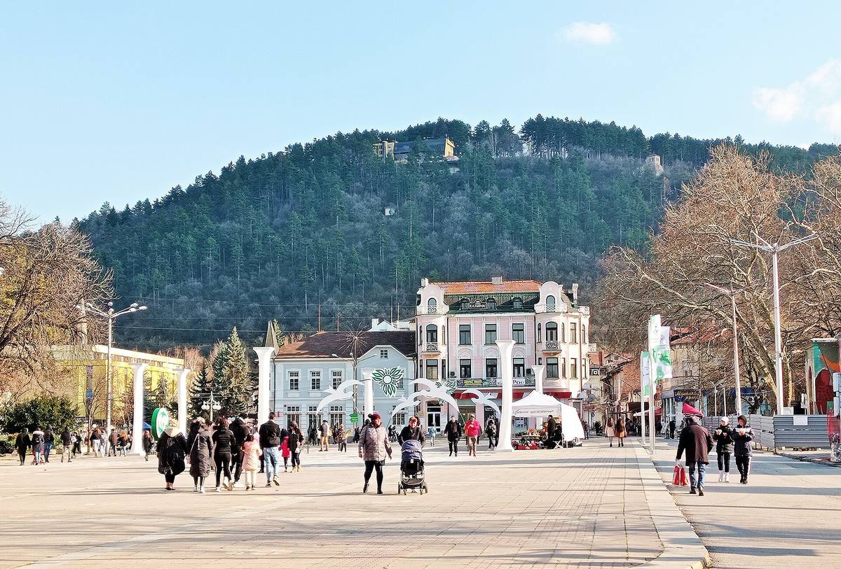
The image could not load. Its caption and source remain available.

Kyustendil's central square, about 110 by 50 m, was designed by the architect Hristo Kovachevski. Beneath it runs the main street of Roman Pautalia, today an archaeological monument of national importance. This was the southern edge of the Ottoman center, and it is where the town gathers for Kyustendil Spring and on August 15, for the blessing of the waters on the feast of the Dormition.
Hours, admission, and directions ↓
A pedestrian square that opens to the south onto the wooded slopes of Hisarlaka. On the east it is closed by the red Town Hall, on the west by the park. Around it are also the Post Office and the Tourist Information Center, Wikipedia writes. “Velbazhd” is the medieval name of the town, the successor of Roman Pautalia.
Under the square: Pautalia
↗Beneath the square runs the main street of the Roman town, the decumanus maximus. It is in the Ministry of Culture’s list of cultural monuments of national importance (2006) as “Decumanus maximus I,” an archaeological monument declared in the State Gazette, No. 25/1998. The list traces its course through several blocks: under the square and through the park to the west of it, on the site of the former Bratstvo community center (chitalishte).
The whole town center, “the ancient and medieval town of Pautalia-Velbazhd,” was declared an architectural and archaeological reserve in 1977. We found no visible remains of the street on the square itself.
The southern edge of the Ottoman town
↗Wikipedia writes that the Ottoman clock tower, the Sahat Kula, was built in 1665. It stood 30-40 m northeast of today’s Church of the Assumption, at the southern edge of today’s square. It was pulled down after the Liberation. Its bell of 1429 still strikes in the turret of the Town Hall (see the Town Hall page).
Before 1878, the site of the Town Hall was taken by the mansions (konaks) of Ottoman notables, among them Zeynel Bey. They left for Macedonia in 1878.
A new center after the Liberation
↗The State Archives in Kyustendil (2019) credit the town’s European look to two town architects. Libur Bayer drew the first town plan after the Liberation. Rudolf Fischer designed some of the buildings in the center, the Iron Bridge, and the station.
In 1889-1894 the Pedagogical School, now the Town Hall, was built on the east side of the square. The square’s proportions, 110 by 50 m, were set by the architect Hristo Kovachevski, Wikipedia writes. Kovachevski was a native of Kyustendil who had studied architecture in Vienna, and in 1906-1909 he headed the municipality’s technical department. Wikipedia links these proportions to the “golden ratio,” but the numbers don’t bear it out: 110 by 50 gives 2.2, while the golden ratio is about 1.618.
The first town garden, with a refreshment bar and summer parties with music, was “on the site of today’s Velbazhd sports complex,” write Ekaterina Keremidarska and Mihal Nikolov in Kyustendil Readings, published by Sofia University (1996). In 1893 the municipality hired a gardener for it, Georgi Tsvetkov from Sofia. They also write that in 1886 the Dragoman hotel and café was built “in the center of Kyustendil,” a meeting place for senior officials and the officers of the garrison.
The State Archives also keep the town’s later plans. The general town plan dates from 1924. The plan of 1939 came into legal force before Sofia’s.
The community center that is gone
↗On the west side of the square, in a park, stood the building of the Bratstvo community center. It was built to Kovachevski’s design in 1907 (Wikipedia’s article on Kovachevski says 1908) and remodeled in 1914 to a design by the architect Balkandzhiev.
In 1981, by decision of the district committee of the Bulgarian Communist Party, the building was demolished “despite the protests of the citizens,” Wikipedia writes. Only part of its east façade was kept. The State Archives (2019) write that this small part “rises on Velbazhd Square today.” The community center still works, in another building.
A square for events
↗- December 4, 1922. During the so-called Kyustendil Action of the IMRO (the Macedonian revolutionary organization), its member Pancho Mihaylov addressed the townspeople on the central square, Wikipedia writes, citing the Encyclopedic Dictionary of Kyustendil.
- March 21, 1966. Kyustendil Spring was declared a town holiday. Every year, on March 21, people gather on the square in front of the old school building and set off from there on a walk to Hisarlaka.
- June 11, 1966. Yuri Gagarin came to Kyustendil. Anton Venev of the Regional History Museum writes (Muzeen Vestnik, 2026): “Even a sudden downpour could not drive the crowd from Kyustendil’s central square.” At the rally Gagarin was made an honorary citizen of the town.
- August 15. On the feast of the Dormition, after the liturgy in the Church of the Assumption, the waters are blessed on the square. In 2024 and 2026 Patriarch Daniil led the blessing; in 2026 it took place “on the small stage of Velbazhd Square,” the Sofia Metropolis writes. The festive loaves are blessed too, in Kyustendil’s “Panagia” rite.
- August 15, 2021. The Osogovo Run, a 26 km mountain race to Ruen Peak, started from the square, the municipality announced.
What is on the square today
↗- The Town Hall, on the east side. It has its own page.
- The Post Office and the Tourist Information Center (according to Wikipedia). We found no date or architect for the post office.
- The park on the west side, with the remnant of the old community center’s façade.
- A war memorial. In 2002 the memorial to two Russian soldiers of the 4th Kharkov Lancers, killed on January 16, 1878, was moved to the town center. Its inscription honors the men of the Rila region who fell in the wars of 1912-1918. So writes Wikipedia, and its coordinates place the memorial about 70 m west of the middle of the square.
- The stage. The Municipal Council named the stage on the central square after the folk singer Olga Borisova, Wikipedia writes.
We found no source for a fountain on the square itself.
Photos and related images
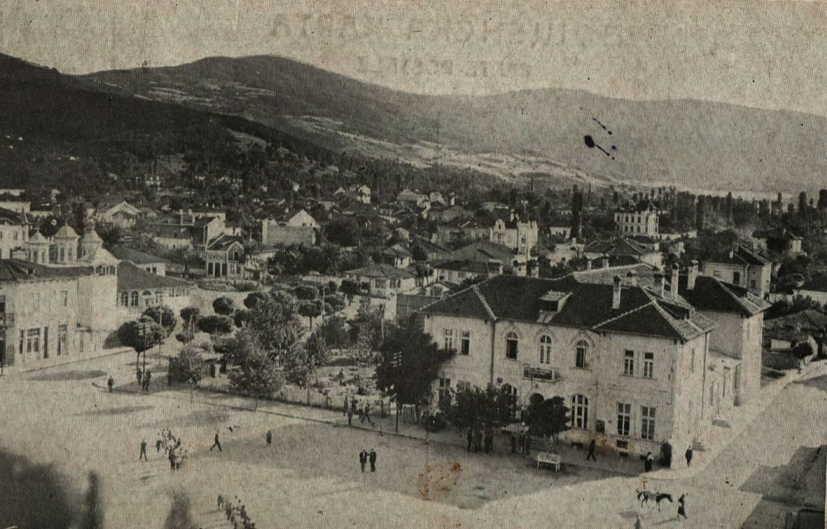
The image could not load. Its caption and source remain available.

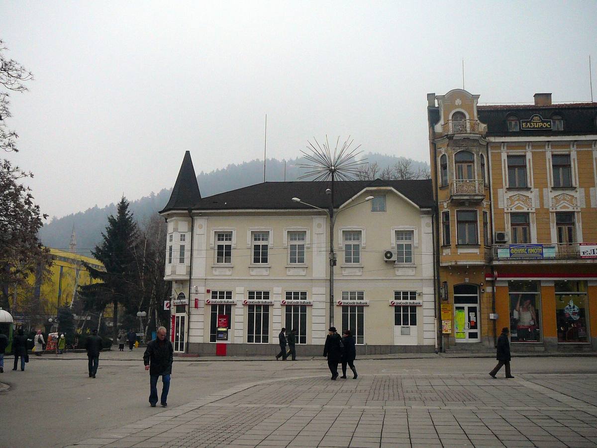
The image could not load. Its caption and source remain available.

Sources
(18)
A date may refer to construction, renewal, or another stated stage. Legends are accounts recorded in sources, rather than established events. Bibliography links help locate the named author; no automatic reference is added where the match is ambiguous.
- Списък на паметниците на културата с национално значение в област Кюстендил, Министерство на културата, 2006PDF document · Bulgarian · mc.government.bg
Source address
https://mc.government.bg/images/NPK/KUSTENDIL.pdf
If a link does not open, use its title, author, and address to search, or consult another listed source.
- Велбъжд (площад), УикипедияEncyclopedia article · Bulgarian · bg.wikipedia.org
Source address
https://bg.wikipedia.org/wiki/Велбъжд_(площад)
If a link does not open, use its title, author, and address to search, or consult another listed source.
- Сграда на Педагогическото училище в Кюстендил, УикипедияEncyclopedia article · Bulgarian · bg.wikipedia.org
Source address
https://bg.wikipedia.org/wiki/Сграда_на_Педагогическото_училище_в_Кюстендил
If a link does not open, use its title, author, and address to search, or consult another listed source.
- Сахат кула, УикипедияEncyclopedia article · Bulgarian · bg.wikipedia.org
Source address
https://bg.wikipedia.org/wiki/Сахат_кула
If a link does not open, use its title, author, and address to search, or consult another listed source.
- Народно читалище „Братство-1869“, УикипедияEncyclopedia article · Bulgarian · bg.wikipedia.org
Source address
https://bg.wikipedia.org/wiki/Народно_читалище_„Братство_%E2%80%93_1869“
If a link does not open, use its title, author, and address to search, or consult another listed source.
- Христо Ковачевски, УикипедияEncyclopedia article · Bulgarian · bg.wikipedia.org
Source address
https://bg.wikipedia.org/wiki/Христо_Ковачевски
If a link does not open, use its title, author, and address to search, or consult another listed source.
- Показаха общия градоустройствен план на Кюстендил от 1924 г. (Държавен архив, Кюстендил), Инфомрежа, 2019Online source · Bulgarian · infomreja.bg
Source address
https://infomreja.bg/pokazaha-obshtiq-gradoustrojstven-plan-na-kiustendil-ot-1924-g-69714.html
If a link does not open, use its title, author, and address to search, or consult another listed source.
- Екатерина Керемидарска, Михал Николов. Отдихът и развлеченията на кюстендилци след Освобождението. Кюстендилски четения 3, СУ, 1996, 38-47Research publication · Bulgarian · periodicals.uni-sofia.bg
Source address
https://periodicals.uni-sofia.bg/index.php/KRe/bg/article/view/kre-1996a-06
If a link does not open, use its title, author, and address to search, or consult another listed source.
- Антон Венев. 60 години от посещението на Юрий Гагарин в Кюстендилски регион, Музеен вестник, бр. 28, РИМ, Кюстендил, 2026PDF document · Bulgarian · kyustendilmuseum.bg
Source address
https://kyustendilmuseum.bg/uploads/MUZEEN_VESTNIK_2026_cveten_3.pdf
If a link does not open, use its title, author, and address to search, or consult another listed source.
- Кюстендилска акция на ВМРО, УикипедияEncyclopedia article · Bulgarian · bg.wikipedia.org
Source address
https://bg.wikipedia.org/wiki/Кюстендилска_акция_на_ВМРО
If a link does not open, use its title, author, and address to search, or consult another listed source.
- Кюстендилска пролет, УикипедияEncyclopedia article · Bulgarian · bg.wikipedia.org
Source address
https://bg.wikipedia.org/wiki/Кюстендилска_пролет
If a link does not open, use its title, author, and address to search, or consult another listed source.
- Руски и съветски паметници в Кюстендилска област, УикипедияEncyclopedia article · Bulgarian · bg.wikipedia.org
Source address
https://bg.wikipedia.org/wiki/Руски_и_съветски_паметници_в_Кюстендилска_област
If a link does not open, use its title, author, and address to search, or consult another listed source.
- Патриаршеска литургия и молебен в Кюстендил за празника Успение, Софийска митрополия, 2024Online source · Bulgarian · mitropolia-sofia.org
Source address
https://mitropolia-sofia.org/2024/08/16/патриаршеска-литургия-и-молебен-в-кюс/
If a link does not open, use its title, author, and address to search, or consult another listed source.
- Празникът Успение Богородично в Кюстендил, Софийска митрополия, 2026Online source · Bulgarian · mitropolia-sofia.org
Source address
https://mitropolia-sofia.org/2026/08/16/празникът-успение-богородично-в-кюст/
If a link does not open, use its title, author, and address to search, or consult another listed source.
- Осогово Рън 2021, Община КюстендилInstitutional page · Bulgarian · kyustendil.bg
Source address
https://kyustendil.bg/index.php?option=com_k2&view=item&id=1244
If a link does not open, use its title, author, and address to search, or consult another listed source.
- Олга Борисова, УикипедияEncyclopedia article · Bulgarian · bg.wikipedia.org
Source address
https://bg.wikipedia.org/wiki/Олга_Борисова
If a link does not open, use its title, author, and address to search, or consult another listed source.
- Площад „Велбъжд“, opoznai.bgOnline source · Bulgarian · opoznai.bg
Source address
https://opoznai.bg/view/ploshtad-velbajd-kiustendil
If a link does not open, use its title, author, and address to search, or consult another listed source.
- OpenStreetMap: Площад ВелбъждMap record · Bulgarian · openstreetmap.org
Source address
https://www.openstreetmap.org/way/297186093
If a link does not open, use its title, author, and address to search, or consult another listed source.