64Nature and parks · Above Vrattsa, Osogovo
Matsakov Kamak
Your visit at a glance
- Address
- Osogovo Mountains, above Vrattsa, Kyustendil Municipality
- Suggested time; scope not confirmed
- about 1 hour 30 minutes
- Visiting conditions
- No verified information found
- Admission
- No verified information found
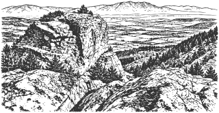
Matsakov Kamak is a rock formation in the Osogovo Mountains above Vrattsa, overlooking the Kyustendil Valley. A forest track provides the approach, but older reports about its waymarks need checking on site.
Hours, admission, and directions ↓
Matsakov Kamak stands above Vrattsa, a village in Kyustendil Municipality, which is distinct from the city of Vratsa in northwestern Bulgaria. It is a separate walk in the Osogovo Mountains and does not require an ascent of Mount Ruen. The rocks are the destination; continuing onto the higher mountain routes is a separate undertaking.
The rock masses and the view
↗Silviya Mihova of the Osogovo Tourist Association describes a visit in November 2019. Her account identifies three principal rock masses, the tallest reaching around 50 m. This is an estimate from a walking account, rather than a published survey measurement. She describes the rock as granite and records views of the Kyustendil Valley, the Lisets Mountains, and Mount Vrashnik.
A 2017 study by Valentin Grozdev and coauthors in Geologica Balcanica examines igneous rocks in the Kyustendil region and Osogovo. Zircon analysis and isotope data establish Paleogene magmatic activity. This is a regional study: it provides neither a separate age for Matsakov Kamak nor a date for the formation of its present rock faces.
The old blue route
↗The tourist association describes an approach from the bus stop in the Dervena locality at the upper end of Vrattsa. An earth track enters beech woodland and reaches the rocks in approximately 30 minutes. The blue waymarks toward Osogovo Hut were already described as unmaintained in 2019.
A field account in Planinarski Forum describes an exploration on May 24, 2022, along the continuation beside the Vrateshka River: an old track becoming a path, river crossings, and overgrown sections higher up. This records one specific exploration. It does not establish that the entire route to the upper mountain is currently cleared and waymarked.
Planning the walk
↗Allow around an hour and a half for the approach, a visit, and the return, with additional time depending on the ground. The older walking time does not guarantee today’s conditions. Check the start of the trail locally, and bring a map, water, and footwear suitable for forest tracks.
Hypothesis or unconfirmed claim The steep rock faces require care. The walking account mentions climbing, but the condition of equipped routes has not been confirmed. Visiting the rocks should not be taken as advice to climb or approach cliff edges. No published visitor schedule or admission tariff was found.
The origin of the name also remains unconfirmed in a scholarly source. A popular explanation referring to a “strong, broad-shouldered person” appears in the walking account; it is not a verified historical etymology.
Sources
(4)
A date may refer to construction, renewal, or another stated stage. Legends are accounts recorded in sources, rather than established events. Bibliography links help locate the named author; no automatic reference is added where the match is ambiguous.
- Силвия Михова, ТД „Осогово“. Мацаков камък, едно запомнящо се кътче от Осогово, 26.11.2019Online source · Bulgarian · td-osogovo.org
Source address
https://www.td-osogovo.org/index.php/moments/latest-news/431-мацаков-камък,-едно-запомнящо-се-кътче-от-осогово
If a link does not open, use its title, author, and address to search, or consult another listed source.
- stefan_iliev38. Синята маркировка от Мацаков камък до връх Човеко в Осогово, Планинарски форум, обход на 24.05.2022Online source · Bulgarian · forum.bg-turist.com
Source address
https://forum.bg-turist.com/viewtopic.php?t=14322
If a link does not open, use its title, author, and address to search, or consult another listed source.
- Valentin Grozdev et al. Analysis of the zircon population and Sr-isotope data of the Paleogene igneous rocks from Kyustendil area, SW Bulgaria, Geologica Balcanica 46 (2), 2017, pp. 143-151Online source · Language not specified · geologica-balcanica.eu
Source address
https://www.geologica-balcanica.eu/journal/46/2/pp.-143-151
If a link does not open, use its title, author, and address to search, or consult another listed source.
- Google Maps: Matsakov Stone, предоставен маркерOnline source · Bulgarian · google.com
Source address
https://www.google.com/maps?cid=17461303666291626654
If a link does not open, use its title, author, and address to search, or consult another listed source.