83Nature and parks · Granchar locality, near Dolna Koznitsa
Cherna Niva Rock Group
Your visit at a glance
- Address
- Rock group beside the Koznitsa Valley, near Vsevizhdashtiyat
- Approximate time for the whole walking outing
- about 2 hours 30 minutes
- Visiting conditions
- No verified information found
- Admission
- No verified information found
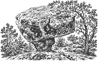
Cherna Niva is a rock group in Granchar locality near Dolna Koznitsa, close to Vsevizhdashtiyat. The published field route connects the two across a ravine without permanent waymarks.
Hours, admission, and directions ↓
Cherna Niva appears as a larger rocky mass across the ravine from the formations around Vsevizhdashtiyat. Eli Ivanova describes visiting both places in February 2026 and explicitly distinguishes them. They therefore have separate guide pages, although one walk can include both. [2]
The rocks from below and above
↗In her Drumi v Dumi account of March 18, 2026, Ivanova notes that Cherna Niva is more striking from below and actually consists of several rocks. The group changes its outline with the viewing angle. After climbing, she reaches its rear and describes open views toward the rocks opposite and Viden Peak.
The site is in the Koznitsa Valley area. The field circuit passes a small tributary crossed during that particular February visit. This observation does not establish equally easy passage after rain or at higher water levels.
A name without secure ancient dating
↗Google Maps uses the label “Cherna Niva megalithic cult complex.” This is a map description for which no confirming archaeological publication was found. An ancient dedication, period of use, or ritual function has not been established for this particular rock group.
Separate scientific literature exists for Dolna Koznitsa. In Kyustendil Readings (Sofia University, 2006), Lidia Staykova-Aleksandrova analyzes a burial mound, dating its burial to 320-285 BC from an imported vessel. That dates a particular burial. It cannot be transferred to Cherna Niva or the surrounding rock depressions.
The shared walk with Vsevizhdashtiyat
↗The published circuit covers 2.7 km from the upper starting point, with about 155 m of ascent. Ivanova gives about an hour of walking. Starting at the main Dupnitsa to Kyustendil road adds roughly 800 m each way. Allow about two and a half hours for the full outing including stops.
The route is unmarked. Its description includes descending into the ravine and climbing without a clear path, rather than a constructed visitor approach with steps. Review the GPS track beforehand and choose a variant suited to vegetation, water levels, and your preparation. The map point identifies the rocks; it is not a parking location or the start of a protected walking path.
Sources
(3)
A date may refer to construction, renewal, or another stated stage. Legends are accounts recorded in sources, rather than established events. Bibliography links help locate the named author; no automatic reference is added where the match is ambiguous.
- Лидия Стайкова-Александрова. Оръжията на античните воини (по материали от могилния гроб при Долна Козница, Кюстендилско), Кюстендилски четения 6, СУ, 2006, с. 9-14Research publication · Bulgarian · periodicals.uni-sofia.bg
Source address
https://periodicals.uni-sofia.bg/index.php/KRe/bg/article/view/kre-2005-02
If a link does not open, use its title, author, and address to search, or consult another listed source.
- Ели Иванова. Мегалитен комплекс в местност Гранчар до с. Долна Козница, Друми в думи, 18.03.2026, посещение на 22.02.2026 и GPS записOnline source · Bulgarian · drumivdumi.com↑1
Source address
https://drumivdumi.com/мегалитен-комплекс-долна-козница/
If a link does not open, use its title, author, and address to search, or consult another listed source.
- OpenStreetMap: node/14028177497, Черна ниваMap record · Bulgarian · openstreetmap.org
Source address
https://www.openstreetmap.org/node/14028177497
If a link does not open, use its title, author, and address to search, or consult another listed source.