82Nature and parks · Granchar locality, near Dolna Koznitsa
Vsevizhdashtiyat Rock
Your visit at a glance
- Address
- Rock group in a ravine beside a tributary of the Koznitsa, Granchar locality
- Approximate time for the whole walking outing
- about 2 hours 30 minutes
- Visiting conditions
- No verified information found
- Admission
- No verified information found
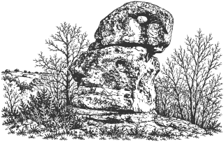
Vsevizhdashtiyat is a rock with an opening near its top, among stone formations in Granchar near Dolna Koznitsa. It can be visited with the neighboring Cherna Niva group on an unmarked route.
Hours, admission, and directions ↓
A rock with an opening near its top rises in a ravine beside a small tributary of the Koznitsa. Maps identify it as Vsevizhdashtiyat, meaning the All-Seeing One. Other stone formations around it can be examined from different angles. They form the first group on the walk described by Eli Ivanova in Drumi v Dumi on March 18, 2026. [2]
Shape and names
↗Ivanova also records the names Halkata, or the Ring, and the One-Eyed Chief, encountered during her research. These are descriptive names rather than established ancient titles. The opening makes the rock recognizable; it does not independently date human intervention or a cult.
Hypothesis or unconfirmed claim The field account explains some shapes through weathering and notes regular outlines and depressions in others. No specialist study was found establishing the origin of every detail. The place is therefore presented as a rock group, distinguishing visible forms from hypotheses about their use.
Archaeology near Dolna Koznitsa
↗In Kyustendil Readings, published by Sofia University, Lidia Staykova-Aleksandrova (2006) examines weapons from a burial mound near Dolna Koznitsa: a bronze helmet, greaves, and shields. That find is a specific archaeological assemblage with a studied inventory. The paper does not identify the burial with Vsevizhdashtiyat or establish a sanctuary at this rock.
The distinction matters when tourist maps use descriptions such as “megalithic” or “cult complex.” Archaeological discoveries in the village lands do not automatically date every nearby stone formation.
An unmarked circuit
↗After consulting the cadastral map, Ivanova places the visited rocks in Granchar locality within Dolna Koznitsa’s lands. She distinguishes them from another group near Blato. The approach begins at a turnoff on the Dupnitsa to Kyustendil road; about 800 m of dirt road lead to her walking circuit’s start.
The described circuit through Vsevizhdashtiyat and Cherna Niva covers 2.7 km, with about an hour of walking from the upper starting point. It includes sections without a clear path and a ravine crossing. From the main road, allow about two and a half hours including the return and time to look around, depending on pace and conditions.
Carry a checked GPS track and suitable footwear. Spring vegetation and stream levels can change the approach compared with the February 2026 visit. This is a field walking route without confirmed permanent maintenance.
Sources
(3)
A date may refer to construction, renewal, or another stated stage. Legends are accounts recorded in sources, rather than established events. Bibliography links help locate the named author; no automatic reference is added where the match is ambiguous.
- Лидия Стайкова-Александрова. Оръжията на античните воини (по материали от могилния гроб при Долна Козница, Кюстендилско), Кюстендилски четения 6, СУ, 2006, с. 9-14Research publication · Bulgarian · periodicals.uni-sofia.bg
Source address
https://periodicals.uni-sofia.bg/index.php/KRe/bg/article/view/kre-2005-02
If a link does not open, use its title, author, and address to search, or consult another listed source.
- Ели Иванова. Мегалитен комплекс в местност Гранчар до с. Долна Козница, Друми в думи, 18.03.2026, посещение на 22.02.2026 и GPS записOnline source · Bulgarian · drumivdumi.com↑1
Source address
https://drumivdumi.com/мегалитен-комплекс-долна-козница/
If a link does not open, use its title, author, and address to search, or consult another listed source.
- OpenStreetMap: node/14028192698, ВсевиждащияMap record · Bulgarian · openstreetmap.org
Source address
https://www.openstreetmap.org/node/14028192698
If a link does not open, use its title, author, and address to search, or consult another listed source.