91Nature and parks · Chudinska Mountains
Kovachitsa Peak
Your visit at a glance
- Address
- Chudinska Mountains, in the area above Ivanovtsi
- Suggested time; scope not confirmed
- Not yet reviewed
- Visiting conditions
- No verified information found
- Admission
- No verified information found
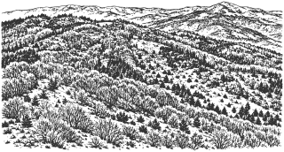
Kovachitsa is a 1,392 m peak in the Chudinska Mountains, in the area above Ivanovtsi. It is distinct from nearby Chukata and is not the range’s highest summit.
Hours, admission, and directions ↓
Kovachitsa lies in the Chudinska Mountains, above the Ivanovtsi area west of Kyustendil. The local geographical overview in BEAM-KN lists it at 1,392 m. The same elevation appears in OpenStreetMap and Alexander Todorov’s recording dated April 25, 2021; the coordinates in the recording’s description closely match the named peak point.
A distinct summit
↗Neighboring Chukata lies about 930 m northeast in a straight line and is lower. The two points identify distinct summits. Their short separation establishes neither a ready-made circular route nor an unobstructed passage along the entire ridge.
In a Sofia University and BAS study published in Problems of Geography in 2023, Rumen Penin and his coauthors describe Chudinska’s rock composition and sparse beech and oak forests on its slopes. These regional findings are not an independent geological survey of Kovachitsa itself.
A detour from the Aramliya route
↗Panayot Tolev’s published route from Lomnitsa through Chudintsi to Aramliya passes through the area. The GPX file attached to its Trips Journal description has an April 8, 2017 date in its metadata. Comparing this with Kovachitsa shows the line passing about 85 m from the summit, so following the recording alone does not establish an ascent to the top. [2]
The author describes an unmarked approach with intersecting roads and overgrown sections. The final detour to Kovachitsa is not documented as a separate maintained path. It needs to be assessed on site, rather than drawn as a straight line across the terrain.
One plan for the day
↗The published Aramliya route is 13.5 km long and takes about 5 hours one way. These figures are not a return distance and time for Kovachitsa. If starting in Lomnitsa, set aside a full day suited to the chosen variant and return journey. If including Chukata too, plan one shared outing; the daily allowances on the two pages should not simply be added together.
Hypothesis or unconfirmed claim The marker is a peak point, rather than parking. Vehicle access to it, a water source, and visitor services on site have not been confirmed. Kovachitsa is distinct from Aramliya; if continuing toward the national border, check conditions for that part of the trip separately.
Sources
(5)
A date may refer to construction, renewal, or another stated stage. Legends are accounts recorded in sources, rather than established events. Bibliography links help locate the named author; no automatic reference is added where the match is ambiguous.
- Румен Пенин, Димитър Желев, Атанас Китев, Таня Стоилкова. Геохимично изследване на тежки метали в ландшафтите на Милевска и Чудинска планина. Проблеми на географията, БАН, 1-2/2023, с. 45-62, особено с. 47PDF document · Bulgarian · geoproblems.eu
Source address
https://geoproblems.eu/wp-content/uploads/2023/06/2023_12/4_penin.pdf
If a link does not open, use its title, author, and address to search, or consult another listed source.
- Панайот Толев. С. Ломница, вр. Арамлия през с. Чудинци, Trips Journal, информация от 06.11.2021; приложен GPX с метаданни от 08.04.2017Online source · Bulgarian · tripsjournal.com↑1
Source address
https://tripsjournal.com/marshrut/selo-lomnitsa-vrah-aramlia-prez-selo-chudintsi
If a link does not open, use its title, author, and address to search, or consult another listed source.
- Александър Тодоров. Връх Ковачица, 1392 м, Чудинска планина, запис от 25.04.2021, публикуван на 27.04.2021; координати в описаниетоOnline source · Bulgarian · youtube.com
Source address
https://www.youtube.com/watch?v=_PwGWSgTJTc
If a link does not open, use its title, author, and address to search, or consult another listed source.
- Чудинска планина, местен географски обзор в BEAM-KNOnline source · Bulgarian · gold.beam-kn.info
Source address
https://gold.beam-kn.info/index.php/ni-riba-ni-rak/12-chudinska-planina
If a link does not open, use its title, author, and address to search, or consult another listed source.
- OpenStreetMap: node/11377574401, Ковачица, 1392 мMap record · Bulgarian · openstreetmap.org
Source address
https://www.openstreetmap.org/node/11377574401
If a link does not open, use its title, author, and address to search, or consult another listed source.