90Nature and parks · Chudinska Mountains
Chukata Peak
Your visit at a glance
- Address
- Chudinska Mountains, northeast of Kovachitsa
- Suggested time; scope not confirmed
- Not yet reviewed
- Visiting conditions
- No verified information found
- Admission
- No verified information found
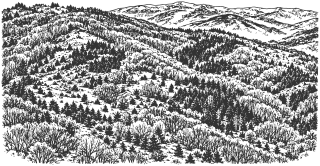
Chukata is a distinct 1,328 m peak in the Chudinska Mountains. The nearby route toward Aramliya passes below it, while reaching the summit requires a detour.
Hours, admission, and directions ↓
Chukata is one of the lower peaks in the Aramliya area of the Chudinska Mountains. Its elevation of 1,328 m agrees between OpenStreetMap’s named peak point and Alexander Todorov’s published recording dated April 25, 2021. This is the particular peak near Kovachitsa; a place with the same name in another range is not interchangeable with it.
The peak and neighboring ridge
↗A comparison of the two map points places Kovachitsa about 930 m southwest in a straight line and 64 m higher. This is a geographical comparison, rather than the distance or ascent along a walking trail. Descending into a saddle and climbing again can make the hike quite different from the difference between the two spot heights.
Writing in Problems of Geography (2023), Rumen Penin, Dimitar Zhelev, Atanas Kitev, and Tanya Stoilkova of Sofia University and BAS describe Chudinska’s gently rolling ridge and high pastures. This characterizes the mountain range, rather than providing a field description of every point on Chukata.
Near the Aramliya route
↗Panayot Tolev’s Trips Journal route runs from Lomnitsa through Chudintsi to Aramliya, with a published distance of 13.5 km and a one-way time of about 5 hours. The description carries information dated November 2021; the attached GPX file has an April 8, 2017 date in its metadata. It describes unmarked sections, intersecting dirt roads, and overgrowth. [2]
Comparing this recording with the peak point shows the line passing about 120 m from Chukata. Following the Aramliya route therefore does not automatically mean climbing this summit. A separate maintained path for the final detour has not been established.
Planning
↗Set aside a full day for an outing from Lomnitsa and plan the return in advance. The published 5 hours concern Aramliya; they are not a measured return time for Chukata. The full-day allowance here is an editorial planning estimate, rather than a guaranteed duration.
Carry a detailed map and check conditions along your chosen approach. The marker identifies the summit. It does not establish vehicle access, parking, or drinking water. If continuing toward the border summit of Aramliya, check current conditions for that route separately.
Sources
(4)
A date may refer to construction, renewal, or another stated stage. Legends are accounts recorded in sources, rather than established events. Bibliography links help locate the named author; no automatic reference is added where the match is ambiguous.
- Румен Пенин, Димитър Желев, Атанас Китев, Таня Стоилкова. Геохимично изследване на тежки метали в ландшафтите на Милевска и Чудинска планина. Проблеми на географията, БАН, 1-2/2023, с. 45-62, особено с. 47PDF document · Bulgarian · geoproblems.eu
Source address
https://geoproblems.eu/wp-content/uploads/2023/06/2023_12/4_penin.pdf
If a link does not open, use its title, author, and address to search, or consult another listed source.
- Панайот Толев. С. Ломница, вр. Арамлия през с. Чудинци, Trips Journal, информация от 06.11.2021; приложен GPX с метаданни от 08.04.2017Online source · Bulgarian · tripsjournal.com↑1
Source address
https://tripsjournal.com/marshrut/selo-lomnitsa-vrah-aramlia-prez-selo-chudintsi
If a link does not open, use its title, author, and address to search, or consult another listed source.
- Александър Тодоров. Връх Чуката, 1328 м, Чудинска планина, запис от 25.04.2021, публикуван на 27.04.2021; координати в описаниетоOnline source · Bulgarian · youtube.com
Source address
https://www.youtube.com/watch?v=u2doFaIDqgk
If a link does not open, use its title, author, and address to search, or consult another listed source.
- OpenStreetMap: node/11377574484, Чуката, 1328 мMap record · Bulgarian · openstreetmap.org
Source address
https://www.openstreetmap.org/node/11377574484
If a link does not open, use its title, author, and address to search, or consult another listed source.